Help and Advice
Records held by the Presbyterian Historical Society
Copying Records
Finding out what Records are available
Paid Research
Other Points to Note
Understanding Land Divisions in Ireland
Help and Advice
While the Presbyterian Historical Society of Ireland cannot provide a full genealogical research service we will offer help and advice about Presbyterian family history to both on-site visitors and to remote enquirers. If you receive helpful advice and guidance from the Society we would really appreciate a donation for the support of the work of the Society.
Records held by the Presbyterian Historical Society
Our database of ministers serving in Ireland from the early 17th century may be of interest if you had Presbyterian ministers in your ancestry – details include when they were born, where they were educated, the churches they served in, when they retired and died and sometimes when and who they married.
A summary of this information is available in the printed Fasti for those PCI ministers ordained between 1840 and 1910 and is available for purchase (£7.50 for a set of 3 Parts, plus postage and packing).
A similar Fasti is available for Seceder Ministers, 1746-1948 (£5.00, plus postage and packing).
The Society holds an almost complete set of microfilms of registers of baptisms and marriages and other records of the Presbyterian Church in Ireland, the Reformed Presbyterian Church of Ireland and the Non-Subscribing Presbyterian Church of Ireland. We also hold some congregational records that have not been microfilmed or copied in other formats.
Copying Records
You should note that we are unable to print out entries from microfilms but we can provide xerox or electronic copies of original records or Xerox copies held.
Finding out what Records are available
Very often enquirers want to know what records are available for a particular church or in a certain area; the easiest way of finding out this information is to consult PRONI Guide to Church Records on the website of the Public Record Office of Northern Ireland (PRONI). The Guide lists all church records by civil parish and indicates what is available, for what dates and where to find the records.
New County Guides to Presbyterian Congregational Records are now available on this website. The details in these are more comprehensive than PRONI's Guide to Church Records
All Presbyterian churches material held in the Public Record Office of Northern Ireland and in the Presbyterian Historical Society of Ireland will be found under the following reference numbers (as used in the PRONI eCatalogue system):
- Presbyterian Church (those associated with the General Synod of Ulster, the Seceder Synods and the General Assembly of the Presbyterian Church in Ireland – MIC1P (on microfilm) or CR3 (original or xerox copy)
- Non-Subscribing Presbyterian Church – MIC1B (microfilm copy) or CR4 (original or xerox copy)
- Reformed Presbyterian Church – MIC1C (microfilm copy) or CR5 (original or xerox copy)
More information about the types of congregational records held by the Society.
Paid Research
If the Society is the only holder of a particular document then we can offer a paid research service (the charge is £10.00 per hour or part thereof - payment can be made through PayPal). Any other searches will be at the discretion of the Librarian/Archivist and is dependent on the enquirer giving reasonably precise information.
The basic information that is required:
- Where the family lived – a townland or parish if possible (see below for an explanation of the different land divisions in Ireland).
- The name of the Presbyterian church, if known.
- Any dates of baptism and marriage and where they took place, if known.
If you require detailed research carried out and are unable to do it in person you should contact a commercial genealogical organisation.
Other Points to Note
Marriages
Until 1782 it was illegal for Presbyterian ministers to conduct marriages and not until 1845 were all restrictions lifted on marriages performed by Presbyterian ministers. Therefore it is always advisable to check the registers of the local Church of Ireland parish up to the early 19th century.
Burials
As very few Presbyterian churches had or have a graveyard attached, the practice of recording burials was not widespread and the number of registers recording these details are few. Some gravestones in Presbyterian graveyards have been transcribed – see www.historyfromheadstones.com or the volumes of Gravestone Inscriptions produced by the Ulster Historical Foundation (largely for County Down and mainly up to 1864). There are some free websites - for gravestone inscriptions, see IGP Headstone Project ; for burial records for three of the cemeteries managed by Belfast City Council (Belfast City from 1869, Dundonald from 1905 and Roselawn from 1954), see Belfast City Burial Records ; and for Derry City Cemetery Records .
Civil Registration of Births, Marriages and Deaths
The easiest and quickest way to find births and deaths from 1864 onwards, Protestant marriages from 1845 onwards and all other marriages from 1864 onwards is to consult the civil registers of births, marriages and deaths.
Civil Registration in Ireland was introduced in 1845 for Protestant marriages and then in 1864 for births and deaths and for all other marriages. These records are held at the General Register Office Northern Ireland (www.nidirect.gov.uk/gro) for Northern Ireland only, and at the General Register Office Ireland (Oifig An Ard-Chláraitheora) for those in the Republic of Ireland and in Northern Ireland up to 1922. A birth record will record the date and place of birth, the name and residence of the father, the maiden name of the mother, the occupation of the father and the signature and qualification of the informant. A marriage record will record the date of the marriage, the names and residence of the bride and groom, their ages (often only states 'full age' ie over 21) and their occupations as well as the signatures of witnesses. A death record will record the date and place of death, their age, occupation, cause of death and signature and qualification of the informant.
The General Register Office Northern Ireland now has a GRONI online service - giving access to the indexes and images for a fee - births over 100 years old, marriages over 75 years old and deaths over 50 years old. By visiting the GRONI Public Search Room in Belfast or at the Public Record Office of Northern Ireland a more extensive range of records is available.
IrishGenealogy.ie is a website, operated by the Department of Arts, Heritage, Regional, Rural and Gaeltacht Affairs, that allows users the opportunity to search a wide range of record sources in their search of their Irish Ancestry. Online searching gives free access to the historic civil records of births, 1864-1922, marriages, 1845-1922 and deaths, 1864-1922 for the whole island of Ireland including images of the actual entries. You can also search marriages, 1923-47, and deaths, 1923-72, for the Republic of Ireland.
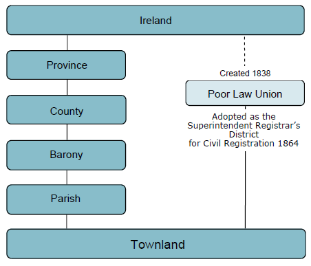
Understanding Land Divisions in Ireland
The main land divisions in descending order of size are as follows:
The Province
The province is the oldest land unit in Ireland which had its origins in the ancient lordships. Today there are 4 Provinces – Ulster in the north, Leinster in the east, Connaught in the west and Munster in the south. The old Province of Ulster once consisted of 9 counties – Antrim, Armagh, Cavan, Donegal, Down, Fermanagh, Londonderry, Monaghan and Tyrone. Northern Ireland is sometimes referred to as ‘Ulster’ but today only consists of Counties Antrim, Armagh, Down, Fermanagh, Londonderry and Tyrone.
The County
The County, created by the English administration in Ireland in the years after the Anglo-Norman invasion of Ireland, is a subdivision of a Province and is the equivalent of an English shire. Counties evolved over a period of time from the late 12th century but it was not until the early 17th century that the present county boundaries were more or less settled. The 9 counties of the historic province of Ulster were first listed in 1608 and included the County of Coleraine which was renamed County Londonderry after the Plantation of Ulster and was formed by amalgamating the barony of Loughinsholin which had been in County Tyrone with the old County of Coleraine. The county was the basis of the great 17th century surveys such as the Civil Survey, Petty’s Down Survey and the Books of Survey and Distribution, became the principal unit of administration for justice in Ireland and was used in all the 19th century census returns. Today there are 32 counties in the island of Ireland, 6 of which are in what is now Northern Ireland (see The Province above).
The Barony
The Barony was an ancient subdivision of a county. It arose in the medieval period from the process of bringing Irish tribal kingdoms into the feudal system of baronies under chieftains owing allegiance to the English crown. However, this system did not extend to Ulster until the early 17th century. There are over 300 baronies in the island of Ireland, of which 59 are in what is now Northern Ireland.
The Parish
The parish was originally an ecclesiastical division dating from the 12th century based on early Christian and monastic settlements and is made up a number of townlands (see The Townland below). The Church of Ireland adopted the medieval pattern of parishes which were largely adopted as civil administrative units though they do not always coincide. Civil parishes became the most important administrative units for land valuation and taxation purposes. They could vary in size from 2 to over 200,000 statute acres and could contain from 5 to 30 townlands. Their boundaries sometimes crossed barony and county boundaries. It should be remembered that the Roman Catholic Church produced its own parish network so many Roman Catholic parishes are made up of parts of several civil parishes. There are about 2500 parishes in the island of Ireland, of which 268 are in what is now Northern Ireland.
The Townland
The Townland was originally a unit of landholding in pre-Norman times, is the smallest territorial unit varying in size from just over 1 acre to more than 7,000 acres but the average size is about 350 acres. The smallest townland in Northern Ireland is Acre McCricket in County Down with 4 acres. There were other ancient divisions in Ireland such as tates, ballyboes and quarters but when the Ordnance Survey began to map Ireland in the 1830s the term ‘townland’ was applied to all of them and hence the great variety in the size of townlands. Generally, townlands are smaller on good land and larger on poorer land. There are approximately 62,000 townlands in the island of Ireland and about 9,500 in Northern Ireland.
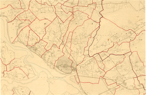
In theory, a townland is within a parish, a parish is within a barony, a barony is within a county and a county is within a province. In practice, this is generally true but there are exceptions - some civil parishes are in more than one barony and sometimes in more than one county.
The Poor Law Unions and Superintendent Registrars’ Districts
There is one further administrative division that you should be aware of and that is the Poor Law Union.
Poor Law Unions were established in 1838 to administer the Irish Poor Law and centred round the market towns where a workhouse was to be located. The boundaries of Poor Law Unions often crossed barony, county and parish boundaries but never intersected townland boundaries. 130 Unions were established and the number increased to 163 by 1850. At the introduction of the system there were 28 Unions based on towns in the counties that are in what is now Northern Ireland .
The Poor Law Union is important to the family historian because when civil registration of births, marriages and deaths was introduced for the entire population in 1864 the Superintendent Registrars’ Districts, created for registration purposes, were based on Poor Law Unions. Therefore, if you are looking for a birth, marriage or death entry post 1864 you need to know in which Poor Law Union the townland of your ancestors is located. You can discover this by consulting the General Alphabetical Index to the Townlands and Towns, Parishes and Baronies of Ireland published in 1861 based on the data from the 1851 Census of Ireland. The census authorities also used the Poor Law Union as the basis for publishing their data.
The importance of land divisions for the family history researcher
To locate your family in a townland greatly enhances the possibility of tracing your family history. You will need to know which parish the townland is situated in order to identify which churches the family may have attended.
Helps for Searching
There are resources on various websites that will help you in your locality research - eg the local history Geographical Index in the Public Record Office of Northern Ireland links every townland to a parish within a county. It will also provide you with an outline map showing the relative location of the parishes within a county in case you need to search for churches in neighbouring parishes should the townland be situated near to the boundary of the parish.
An online Map of Boundaries display facility is available on the Placenamesni.org website - this helps to show barony, parish and townland boundaries overlaid on a map of Northern Ireland.
For other parts of Ireland the OSI Mapviewer facility on the Ordnance Survey Ireland website may be useful in showing townland boundaries on the Historic 6 Inch Series Maps.
The IreAtlas Townland DataBase has search facilities to help find Townland, Parish, Barony and County details.
PRONI Historical Maps
The PRONI Historical Maps viewer can be used to search and browse seven historical OSNI maps and four modern basemaps (including aerial imagery). The viewer displays county, parish and townland boundaries and includes information on sites, buildings and landmarks of historical interest. A variety of tools and 'widgets' enable you to search and browse the maps, compare one map with another, and find various points of historical interest. Search using the PRONI Historical Maps viewer . A useful User Guide for the PRONI Historical Maps viewer is available. See also the video help How to Use Online Historical Maps Viewer.